Search this site
Visualizing the Berlin Wall through Photos and Embroidery


“Due to its geography, proximity to various bodies of water, and very small size, the small village of Klein Glienicke was completely surrounded by the Berlin Wall, such that it was completely impossible to be anywhere in the village where you could not see the Wall,” the artist Diane Meyer tells me. “It was also one of the most densely guarded areas of the Wall. The village was so narrow that neighbors on opposite sides of the Wall lived close together and could see one another, but they were forbidden to speak or even wave to one another.
“Walking through the village, I found it very peaceful and bucolic. It was so hard to imagine what it had been like in the not-so-distant past.” Meyer started photographing sites along the 100-mile path where the Wall once stood during a residency in Berlin. While she hadn’t initially planned to explore the Wall and its history, she spent much of her days wandering the city, inevitability coming face-to-face with reminders of the past.
“As I was walking through the city, I became really interested in the Wall and realized how little I actually knew about it,” she explains. “I remember watching the Wall fall on TV when I was thirteen, but I hadn’t realized it was a ring that completely enclosed West Berlin, and I didn’t realize how far it extended into the suburbs and the surrounding forests–only about 20% of it runs through the city center.
“I also didn’t realize there were actually two walls–an inner and outer wall—and how much physical space in the city was taken up by it. I didn’t realize how much it would be part of one’s visual experience on a daily basis. The Wall went up very quickly, and it was striking to think how family and friends who were neighbors were suddenly separated from one another–and the various ways in which people were able to escape, including on a tightrope, in a hot air balloon, and through underground tunnels.”
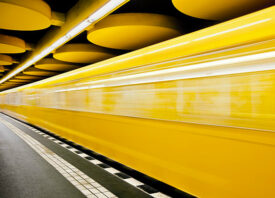
Meyer would make two trips to Berlin, retracing the path of the Wall with help from an app that shares its name, Berlin Wall. “Created by Zentrum für Zeithistorische Forschung and the Bundeszentrale für Politische Bildung, the app uses GPS to show the exact locations of the inner and outer walls,” she explains. She mostly biked throughout the suburban and rural areas, loading her bike on and off the S-Bahn as she made her way along the path.
During both of her visits to the city, it rained or snowed. The winter she was there was the coldest in four decades; her fingers went numb while reloading her medium format camera. In spring, the city was lush and green, and the more rural areas smelled of forest. Taking advantage of one sunny day, she covered 40 miles of the Wall between sunup and sundown.
“It was interesting to see the wide array of the kinds of places occupied by the Wall,” the artist admits. “It ran through forests, used lakes as natural boundaries, cut through suburban neighborhoods, and went through more industrial areas. I remember the space feeling very activated. Even in spots where the Wall was completely absent, there was a disquieting and strong feeling of its presence.”
When Meyer returned home to Los Angeles, she visualized that ghostly presence by embroidering 43 of the photos she’d created in Berlin. The stitches, which coincide with where the wall used to be, are evocative of pixels, a conscious choice meant to represent the corruptibility of memory. She referred to historical photographs and pictures from Los Angeles’s Wende Museum to determine the most accurate placement of the Wall.
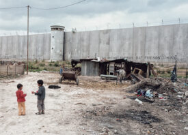
Though the Wall itself was gone, the artist did notice hints of the presence it left behind. “On the edges of the city center, particularly near Neikölln or Alt-Treptow or Plänterwald, there were empty tracts of land or construction sites which provided an indication of where the Wall had been,” she explains. “Since there was an inner and outer wall, there was a large space in between the walls (about 300 feet) known ominously as ‘the death strip’ where guards and dogs would patrol to make it more difficult to escape.
“One would have to get over two different walls and across this space to leave the East, making it almost impossible. Since this whole installation took up so much space, and all of that land opened up so suddenly after 1989, there were several lots in the city center that were still vacant. Also, there would be occasional lights facing the wrong direction or randomly placed that had been left over from the Wall installation. In one case in the city center, there was an apartment building just isolated in an otherwise empty space.
“There were also not-so-subtle clues like several guard towers that were intentionally left to serve as a reminder for future generations not to repeat the mistakes of the past. In Germany, there is a long word for this, Vergangenheitsbewältigung, which translates to ‘overcoming the past’ and is about coming to terms with history- something which sadly does not happen very much in the US.”
Berlin’s landscape continued to transform over the course of Meyer’s project, which began in 2012. “As I completed the series, I went onto Google Earth to look at satellite images to find the street names of many of the locations. Although I had taken notes while I was photographing, I shot around 150 rolls of medium format film, and especially with the passing of time, I had to go back and try to find some of the locations.
“I was shocked by how different the city appeared in 2019. Most of this is related to construction, but I also saw new museums pop up or change location. I also saw a lot of strange juxtapositions, such as a family drinking wine and having a meal in a very nice, modern house immediately next to a guard tower in Nieder Neuendorf. I ended up not including this image in the series, but it was a striking juxtaposition.”
Meyer’s relationship to the work also shifted, especially as she heard talk of a different wall closer to home. “When I started this project, Barack Obama was the President,” she says. “I never would have imagined how delicate and fragile democracy and democratic institutions in the US would now feel just ten years later. Just as the meaning of photographs changes over time, based on the cultural or historic moment, sadly, the implications and meanings of this project have changed for me in ways I didn’t expect given the current moment and the 2016 election.”
On August 13th, 1961, the Berlin Wall appeared virtually overnight, with people waking in the morning to find themselves separated from friends and family by fencing and barbed wire. “In most cases, it takes me longer to embroider one of the pieces than it did for the Wall to be built,” Meyer tells me. While the smallest pieces can require only one or two days, many take months. She spent years working on the piece with the most stitching, Brandenburg Gate. Containing an estimated 17,000 stitches, that particular piece features the landmark site that was reopened on December 23rd, 1989, as rain fell and thousands rejoiced.

There were other sites that Meyer carried with her as she returned home. “Places made impressions included Invalidenfriedhof–a cemetery that was divided in half by the Wall–and Sacrower Heilandskirche, a very beautiful 19th Century Church that was completely cut off by the wall. The campanile of the church actually became part of the Wall. As the other side of the church was surrounded by a lake, it became inaccessible.


“I was also very struck by Bernauer Strasse, which is a very busy and active street but was divided in half by the Wall. In many apartments, the front of the building was in the East, but the back windows overlooked the West and were completely bricked over to prevent people from escaping from East Germany by jumping out of their apartment windows.
“I do think that for some residents, the Wall must still be in their heads. It’s hard to imagine how the Wall would be so much a part of one’s visual experience on a daily basis and how strange it must be for it to no longer be there. As I walked through the city, I wondered about how people’s walking commutes would have changed once the wall was constructed in order to avoid it. That made me curious if people still walk on particular routes through the city out of habit, even if it is no longer the shortest distance between two points and they are no longer blocked by the Wall.”


All images © Diane Meyer