Search this site
Mesmerizing Satellite Photos Show How Much We’ve Changed the Natural World

52.276355786°, 4.557080790°. Tulip fields in Lisse, Netherlands

34.715427913°, -102.507400464°. Cattle are visible at a feedlot in Summerfield, Texas, USA. Once the animals reach a weight of 650 pounds, they are moved to these facilities and placed on a strict diet of specialized animal feed. Over the next three to four months, the cows gain up to 400 more pounds before they are shipped off to slaughter. The lagoon seen at the top of this feedlot gets is glowing color from a high concentration of manure and chemicals.
From the obsidian depths of the cosmos, the planet Earth is but a grain of blue, anchored only by the gravitational pull of the sun and sheltered merely by a slender membrane of atmosphere. In the 1980s, writer Frank White called it “The Overview Effect”: an almost all-consuming sense of reverence and responsibility that pierces the psyches of astronauts as they peer down at the round and floating gem that is our eternal home.
Artist Benjamin Grant harnesses the potency of the Overview Effect by creating Daily Overview, an Instagram account devoted to showcasing the Earth from above. It’s not the picturesque wilderness he’s after but visions for more discomfiting.
He researches the ways in which we as a species have razed and severed the land and sea, partitioned and organized nature to feed our own avarice. From there, he pulls satellite images made by DigitalGlobe and used on Google Earth, overhead shots that evidence without a speck of uncertainty the often brutal hand of mankind.
In picturing the sites where humans have interfered with—and in many ways broken—the face of the Earth, Grant allows us to take on for just a brief moment the role of the gods, of Kubrick’s Star-Child, occupying the empty expanse that surrounds this one precious globe.
No longer are we mere inhabitants of our home planet but its guardians, appointed by default after having wrought so much destruction. Indeed, the beauty and poetry of Grant’s images does nothing to detract from their message; instead, their loveliness amplifies his directive to step back, to notice our seemingly invulnerable world for the delicate nucleus it truly is.

-33.0290936,-71.646348. Valparaíso, Chile is built upon dozens of steep hillsides overlooking the Pacific Ocean. Known as “The Jewel of the Pacific,” the city is the sixth largest in the county and is home to approximately 285,000 residents. Valparaíso is also home to the country’s first public library, South America’s first volunteer fire department, and the world’s longest running Spanish language newspaper in continuous publication.

26.113889, -80.193611. Melrose Park is a residential community in Fort Lauderdale, Florida, USA. The neighborhood is planned with streets in eight concentric octagons and contains 1,975 households.

38.483377775°, -109.681333272°. Blue evaporation ponds are visible at the Intrepid Potash Mine in Moab, Utah, USA. The mine produces muriate of potash, a potassium-containing salt used widely by farmers in fertilizer. The salt is pumped to the surface from underground brines and dried in massive solar ponds that vibrantly extend across the landscape. As the water evaporates over the course of 300 days, the salts crystallize out. The water is dyed bright blue to reduce the amount of time it takes for the potash to crystallize; darker water absorbs more sunlight and heat.

14°33N 121°02E. Makati City is one of sixteen cities that constitutes Manila, the capital of the Philippines. As seen in this Overview, the architecture of the city has a fascinating blend of Spanish colonial architecture and modern skyscrapers.

40.360051, -3.564548. The A-3 and M-50 highways come together in an interwoven crossroads southeast of Madrid, Spain. This type of interchange is commonly referred to as a “spaghetti junction.”

53.0066°N 7.1920°E. Bourtange is a star fort located in the Netherlands. The complex was built in 1593 in the manner you see here so that an attack on any of its five walls could be aggressively counteracted from the two adjacent star points. The village currently has an occupation of 430.

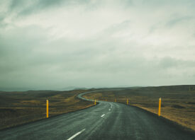
32°51’6″S 70°8’16″W. Los Caracoles Pass, or The Snails Pass, is a twisting mountain road located in a remote section of the Andes Mountains on the Chilean side of the border with Argentina. The path climbs to an elevation of 10,419 feet, has no roadside safety barriers, and is frequented by large trucks.

39°2753N 0°2212W. The urban plan of the L’Eixample district in Valencia, Spain is characterized by long straight streets, a strict grid pattern crossed by wide avenues, and apartments with communal courtyards. A similar layout was used for the district of the same name in Barcelona. The circular structure in the upper right is the Plaza de Toros de Valencia – the city’s largest bullfighting arena.

46°0450N 07°2414E. The Grande Dixence Dam in the canton of Valais in Switzerland is the tallest gravity dam in the world with a height of 935 feet (285 m). A gravity dam resists the horizontal thrust of the contained water, in this case the Dixence River, entirely by its own weight. The Grand Dixence took 14 years to construct, contains approximately six million cubic meters of concrete, and generates power for more than 400,000 Swiss homes.

17°5528S 25°5124E. Victoria Falls is a waterfall located on the Zambezi River at the border of Zambia and Zimbabwe. While it is neither the highest nor the widest waterfall in the world, it is classified as the largest with a width of 1,708 meters (5,604 ft) and height of 108 meters (354 ft). Accordingly the falls contains the world’s largest sheet of falling water with a flow of approximately 1088 cubic meters per second.

52°4327N 5°3839E. The village of Espel, located in the province of Flevoland, Netherlands, is home to 774 inhabitants. The farms in the region specialize in the growth of flower bulbs.

39.933622168°, 119.683840353°. New data from the Chinese government revealed that the country has been burning up to 17% more coal each year than previously disclosed. While president Xi Jinping recently promised to halt the growth of his country’s carbon dioxide emissions by 2030, the new figures mean that China has been burning an additional 600 million tons of coal each year. The sharp upward revision in official figures means that China has released much more carbon dioxide — almost a billion more tons a year — than previously estimated. This Overview shows the coal terminal at the Port of Qinhuangdao – the largest coal shipping facility in China. From here, approximately 210 million metric tons of coal are primarily transported to coal-burning power plants in the major cities in southern China each year. This figure is believed to account for approximately half of the country’s annual consumption.

48.1914141,16.7793358. Agricultural development surrounds the Austrian villages of Haringsee, Straudorf, and Fuchsenbigl. Of Austria’s total area, 80% of land is used for farming and forestry (67,000 square kilometers of 84,000 square kilometers).

33°5328S 151°1640E. One of the city’s most popular destinations, Bondi Beach in Sydney, New South Wales gets its name from the Aboriginal word “Bondi” that means waves breaking over rocks.

5.263871492°, 115.257723686°. Oil field service ships sit at anchor outside of Labuan, a territory of Malaysia that is located off the coast of Borneo. In addition to being an offshore financial center, Labuan is an offshore support hub for deepwater oil and gas activities in the region. The economy of Labuan is heavily dependent on its fossil fuel resources, which account for 65% of its exports.

27°1449N 140°5228E. Nishinoshima is a volcanic island located 940 kilometers south of Tokyo, Japan. Starting in November 2013, the volcano began to erupt and continued to do so until August 2015. This Overview was captured on 7/1/2015. Over the course of this activity, the island grew in size from .056 square kilometers to 2.3 square kilometers.